
Arrowsmiths – Farmer Township (formerly in Williams County)
Post Office: 1843 – 1866
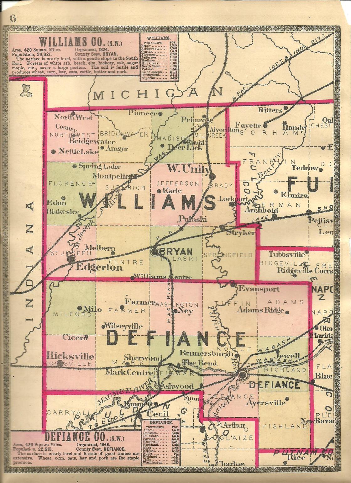
Location: 41.350111, – 84.671121
on SR 2 at the 4-way intersection of Ensign Rd (Co Hwy 62) and Breininger Rd (Township Hwy 119) along Lost Creek
Remnants: Lost Creek Cemetery on the east side of SR 2 at the 4-way intersection of Dalrymple Rd and Blosser Rd (Township Hwy 72) about 1/3 of a mile north of the GPS coordinates, former one-room schoolhouse across the road from the cemetery in the northwest corner of the intersection
Description: The town was founded by Miller Arrowsmith (1808 – 1893) and Celinda (Caraway) Arrowsmith (1813 – 1849) from Champaign County. They got married in 1832, bought a farm at the GPS coordinates in 1833, and had a couple of children. The farm consisted of 275 acres. Miller built a grist mill, operated the post office, and served in the positions of county auditor and county surveyor. Instead of pursuing other public or political offices, which he likely could have had an easier life with, Miller opted to engage in his favorite activity of farming for the remainder of his working years. The former school (Farmer Township No. 9) was on a 100-acre farm owned by the Hilbert family. It was also known as the Lost Creek School and has been converted to a private residence. The Arrowsmiths were buried in Lost Creek Cemetery. A Lutheran church at the cemetery has since been lost to time.
Ashwood (Ashwood Station) – Defiance and Delaware Township
Post Office: 1879 – 1880
Location: 41.255882, -84.457169
on Ashwood Rd at the railroad tracks between Defiance Paulding County Line Rd and US 24
Remnants: none known
Descripton: It was a farming town with a train station on the Wabash Railroad. The proprietors were Frederick J. Harmening (1840 – 1883) from the defunct kingdom of Prussia, Germany and Amelia (Hecht) Harmening (1853 – 1937) from Pennsylvania. They got married in 1873 after Frederick’s first wife passed away. She was a sister of Amelia, Anna (Hecht) Harmening (1844 – 1871) from Germany. Frederick was a successful farmer an entrepreneur. He owned all of section 36 in Delaware Township on the west side of the GPS coordinates, a 153-acre farm on the east side of the GPS coordinates in Defiance township where the train station was, and platted the north half of Mark Center when the B&O Railroad was constructed through that part of Mark Township in 1875. A school (Defiance Township No. 1) was 1 3/4 miles southeast of the GPS coordinates on the west side of Krouse Rd (Co Hwy 146) on a 120-acre farm owned by the Sherry family. Frederick had at least 6 children and was laid to rest with Anna, Amelia, and some other relatives about 5 miles northeast of the GPS coordinates in Riverside (Auglaize) Cemetery on SR 111 (S Clinton St) in the City of Defiance.
Cicero (Cicero Corners) – Milford and Hicksville Township
Post Office: 1852 – 1901
Location: 41.339428, -84.709210
on Cicero Rd (Co Hwy 115) at the intersection of Huber Rd (Township Hwy 61) along North Fork Gordon Creek
Remnants: none known
Description: Cicero had a grist mill, a steam-powered saw mill, and a Methodist Episcopal church in town along Cicero Rd just north of the intersection. A school (Milford Township No. 4) was 1 mile north of the GPS coordinates in the northeast corner of the intersection of Cicero Rd and Arrowsmith Rd. The known postmasters were David M. Grier, E. M. Hattery, John F. Haller, Rosa Miller, William Battershell, and P. L. Battershell. Cicero’s last known cartographic appearance was in the 1931 county atlas. Many residents were buried in Six Corners Cemetery 1 1/2 miles southwest of the GPS coordinates on the south side of SR 2 between Cicero Rd and Lake Rd (Township Hwy 113).
Clarksville – Milford Township (formerly in Williams County)
Location: 41.422196, -84.770018
on Williams Defiance County Line Rd (Def Williams Co Line Rd) at the intersection of Hicksville Edgerton Rd (Township Hwy 109) along the St Joseph River
Remnants: none known
Description: Clarksville was platted with 36 lots in 1836 by Elisha Clark who was the first justice of the peace in the township. A layout of the plat was listed on the Milford Township map in the 1866 county atlas and page 55 of the 1890 county atlas. During its heyday in the mid-1800s there were 2 stores, 2 taverns, 2 doctors, a grist mill, a small Lutheran church, and about 20 houses. The first school was constructed on lot 10 in 1840. It was replaced by a newer building (Milford Township No. 2) about 3/4 of a mile south of the GPS coordinates in the northwest corner of the intersection of Hicksville Edgerton Rd and Kramer Rd on a 39-acre farm owned by the Green family. Clarksville made it into the 1931 county atlas, but the plat had mostly reverted back to farmland by then.
Domerville (Domersville) – Adams Township
Post Office: 1892 – 1899
Location: 41.384162, -84.324039
on Domersville Rd at the intersection of Coressel Rd
Remnants: Domersville (Chase) Cemetery on the west side of Domersville Rd just south of the GPS coordinates, former one-room schoolhouse next to the cemetery, old houses and farm buildings in the area
Description: It was founded by Joshua Domer (1842 – 1915) from Pickaway County and Mary (Sullivan) Domer (1848 – 1918). Joshua was the first known postmaster and Henry J. Cupp (1866 – 1945) from Marion County was the last known postmaster. Henry was buried with relatives and other residents 2 1/2 miles southeast of the GPS coordinates in Saint Michaels Catholic Cemetery on the west side of Moser Rd (Co Hwy 181). A blacksmith shop owned by Charles M. Seibert (1857 – 1910) and Mary (Weaver) Seibert (1859 – 1923) was in the southwest corner of the intersection. They got married in 1882, had 11 children, and were also buried in Saint Michaels Catholic Cemetery. The former school (Adams Township No. 4) and Domversville Cemetery predate the existence of the town. The cemetery was established on a farm owned by county pioneers Charles G. Chase (1815 – 1862) from Nantucket County, Massachusetts and Charlotte (Felton) Chase (1822 – 1860). Charles worked on whaling ships for about 12 years before marrying Charlotte in 1841 and subsequently moving to their farm. They were buried with relatives in the cemetery. Joshua and Mary Domer had a few children and were laid to rest with with relatives in Poplar Ridge Cemetery 3 1/3 miles southeast of the GPS coordinates on the east side of Adams Ridge Rd.
Glenburg – Washington and Tiffin Township, Defiance County and Springfield Township, Williams County
Post Office: 1893 – 1905
Location: 41.427192, -84.458981
on Williams Defiance County Line Rd (Def Williams Co Line Rd) at the intersection of Glenburg Rd
Remnants: old houses and farm buildings in the area
Description: Glenburg was a small farming and postal town. The proprietor and postmaster was Urias L. Chruchman (1851 – 1922) who owned a 79-acre farm on the west side of Glenburg Rd just south of the GPS coordinates. A school (Tiffin Township No. 3) was 2 miles southeast of the GPS coordinates in the southeast corner of the intersection of Scott Rd and Trinity Rd (Co Hwy 147) on a 159-acre farm owned by the Russell family. Urias was buried with relatives in Fountain Grove Cemetery 7 miles northwest of the GPS coordinates at the intersection of US 127 (SR 15 / SR 2) and Williams County C (E Fountain Grove Dr) in Bryan, Williams County.
McCauleys – Tiffin Township
Post Office: 1860 – 1864
Location: 41.369719, -84.419019
on Evansport Rd at the intersection of Kammeyer Rd along the Tiffin River
Remnants: McCauley Cemetery on the west side of the intersection
Description: The proprietors were Philip McCauley (1823 – 1892) from Cumberland County, Pennsylvania and Mary (Wissler) McCauley (1819 – 1899) from Pickaway County. They got married in 1846, owned a 160-acre farm, and had 6 children. Phillip was a school director, justice of the peace, and township trustee. Nelson Slater (1818 – 1887) was the only known postmaster. He moved out of the state and was buried with relatives in Greenwood Cemetery on SR 9 in Lagrange County, Indiana. A school was at the site of McCauley Cemetery in the mid-1800s. The first known interment was Philip’s paternal grandmother, Mary McCauley (1769 – 1855) from Pennsylvania. Philip and Mary were also buried in the cemetery with many relatives and other residents. The Columbus, Lima, & Milwaukee Railroad rolled through the area in the late 1800s. McCauley fell into obscurity long before its arrival though, and the railroad didn’t bring the town back to life.
Midway – Richland Township
Location: 41.275014, -84.266021
on Harris Rd (Township Hwy 188) at the railroad crossing between SR 281 and Standley Rd (Co Hwy 38)
Remnants: old houses and farm buildings in the area
Description: Midway was on the B&O Railroad in the late 1800s to early 1900s. There’s no record of the town having a train station, but it did have an express post office. A school was 1/2 of a mile south of the GPS coordinates in the northwest corner of the intersection of Harris Rd and Standley Rd on a 78-acre farm owned by George C. Wirth (1853 – 1931) from Henry County and Elizabeth (Dietsch) Wirth (1858 – 1939). George passed away just a few months shy of their 50th wedding anniversary, having lived all those years with Elizabeth in Richland Township. They were buried with relatives in Saint Stephen’s Lutheran Cemetery 3 1/3 miles southeast of the GPS coordinates on the west side of New Bavaria Rd in Highland Township.
Milo – Milford Township
Post Office: 1851 – 1884
Location: 41.382707, -84.729055
on SR 249 at the intersection of Lake Rd (Township Hwy 113) along Crooked Creek
Remnants: none known
Description: It was a farming town with a post office that moved around to the houses of its postmaster, serving a wide range of residents near the center of the township. The known postmasters were James Marshall, Jacob Serrill, John Serrill, E. H. Chapman, George W. Chapman, and A. Pearson. Milo had a few local schools. Milford Township No. 6 was 3 miles west of the GPS coordinates in the southwest corner of the intersection of SR 249 and Casebeer Miller Rd. Milford Township No. 7 was 1 mile west of the GPS coordinates in the southwest corner of the intersection of SR 249 and SR 49. Milford Township No. 8 was a mile east of the GPS coordinates in the northwest corner of the intersection of SR 249 and Cicero Rd (Co Hwy 115).
Nebo – Mark Township
Post Office: 1890 – 1904
Location: 41.267009, -84.669182
on Jericho Rd (Co Hwy 33) at the intersection of Breininger Rd (Township Hwy 119) along Gordon Creek
Remnants: former one-room schoolhouse in the lot in the northwest corner of the intersection, Spindler Cemetery on the west side of Breininger Rd 1/3 of a mile south of the GPS coordinates
Description: Nebo was founded by Civil War veteran George Spealman (1834 – 1915) and Blanche (Kirk) Spealman (1840 – 1932). They got married in 1857 and moved to LaSalle County, Illinois the following year. George and Blanche had 3 children there before they returned to Ohio in the mid-1860s and had 2 more children. They owned a steam-powered saw mill which was physically moved from Stark County to Henry County. From there, the mill was relocated about a mile north of Mark Center, and again in to the village of Mark Center. Lastly, the mill was moved to the northeast corner of Nebo’s intersection. George and Blanche also owned a cider mill next to the saw mill and George was the town’s postmaster. The school (Mark Township No. 9) was on a 78-acre farm owned by the Spindler family. It was also know as the Spindler School and has since been converted to a private residence. The cemetery was established on a 160-acre farm owned by John Spinder (1807 – 1906) and Elizabeth Spindler (1810 – 1864) from Pennsylvania. Everyone mentioned in this listing was buried in Spindler Cemetery.
Snooksville (Westburg) (Westburgh) – Delaware Township (formerly in Williams County)
Post Office: 1836 – 1847 and 1851 – 1861
Location: 41.267254, -84.553590
on US 127 at the intersection of Jericho Rd (Co Hwy 33)
Remnants: Blair Cemetery in the woods on private property south of Blair Rd about 1/3 of a mile west of the GPS coordinates
Description: The first known postmaster when it was in Williams County was an M. Evans. Sometime between 1843 and 1846, the “h” was added to the end of the town name. Peter Snook (born c. 1818) was the last known postmaster of the Westburgh office. He was also the first postmaster of the Snooksville office and changed the town name to Snooksville. Peter married Caroline (Whetstone) Snook in 1849. The Snook family disappeared from county records after the 1850 census with their later whereabouts unknown. Peter was succeeded as postmaster by Gilbert Coffin (1808 – 1875) who was laid to rest with relatives in Colby Cemetery on private property 3 miles southwest of the GPS coordinates on the north side of Defiance Paulding County Line Rd (T-8) in Mark Township. Jacob Kintner was the last known postmaster and was buried with relatives 1 3/4 miles north of the GPS coordinates in Sherwood Cemetery on the east side of US 127 (N Harrison St). Its unknown if Jacob Kintner Sr. (1798 – 1869) or Jacob Kintner Jr. (1835 – 1905) was the postmaster. A school (Delaware Township No. 10), also known as the Coffin School, was in the northwest corner of the intersection. Orlando Coffin (1848 – 1907) owned a saw mill on the west side of SR 127 just south of the GPS coordinates and was also buried with relatives in Colby Cemetery. The Blairs were another large and prominent family in the area. Blair Cemetery has 29 known interments of local residents, mostly from the time period when Snooksville existed.
Whites Mills (White City) – Defiance and Delaware Township
Post Office: 1875 – 1876
Location: 41.275371, -84.457498
on County Rd 424 at the intersection of Ashwood Rd along the Maumee River
Remnants: Shoemaker (Tuttle) Cemetery 1/2 of a mile west of the GPS coordinates on the north side of County Rd 424, Hill Cemetery about 1 mile northwest of the GPS coordinates on private property between Tittle Rd (Township Hwy 200) and the river, old houses and farm buildings in the area
Description: This mill and merchant town was on the B&O Railroad in the late 1800s to early 1900s. It had train station, hotel, and 2 saw mills. A school (Delaware Township No. 4) was 1 mile west of the GPS coordinates in the southwest corner of the intersection of County Rd 424 and Whetstone Rd on a 79-acre farm owned by the Jacobs family. Another school (Defiance Township No. 4) was 1 1/2 miles east of the GPS coordinates in the northeast corner of the intersection of County Rd 24 and May Rd on a 70-acre farm owned by German immigrants Deitrich Bohlke (1818 – 1899) and Elizabeth (Gonzales) Bohlke (1821 – 1890). They got married in 1845, had a few children, and were buried in Shoemaker Cemetery.
Wilseyville – Farmer Township
Post Office: 1865 – 1883
Location: 41.351017, -84.678701
on Ensign Rd (Co Hwy 62) between SR 2 and Rosedale Rd (Township Hwy 117) along Lost Creek
Remnants: Lost Creek Cemetery on the east side of SR 2 at the 4-way intersection of Dalrymple Rd and Blosser Rd (Township Hwy 72) about 3/4 of a mile northeast of the GPS coordinates, former one-room schoolhouse across the road from the cemetery in the northwest corner of the intersection
Description: John Derrick Wilsey (1828 – 1920) and Calphurnia (Otis) Wilsey (1835 – 1914) got married in Pennsylvania in 1853 and later moved to Defiance County. They built a boat oar factory on the eastern edge of the Arrowsmith’s farm in the mid-1860s. A post office called Wilseyville was opened to replace Arrowsmiths. The known postmasters were Gideon D. Ensign (1827 – 1887) from Berkshire County, Massachusetts and Civil War veteran William M. Haller (1832 – 1893) from Champaign County. The oar factory was just north of the GPS coordinates next to Lost Creek. Workers lived in boarding house next to Ensign Rd on the Arrowsmith farm. As mentioned in the listing for Arrowsmiths, a Lutheran church was at Lost Creek Cemetery and the former school (Farmer Township No. 9) which was also called the Lost Creek School is now a private residence. John and Calphurnia had a few children and were buried with relatives in Woodlawn Cemetery on Tr 0173 in Bloomville, Seneca County. Wilseyville and Arrowsmiths faded out of existence prior to 1900. Gideon Ensign and William Haller were laid to rest with relatives and other residents in Lost Creek Cemetery.